


Solomon's Porch-Portico
Triple gate
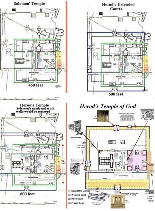
Placing the Temple in the SW corner of the Temple Mount is nothing new. In fact almost all of those men that were allowed to explore the Temple Mount in the 1800's drew their maps with the Temple in a 600 by 600 foot square in the SW corner with the east wall landing at Triple gate. (see Early Explorer's maps) I differ from them because I go beyond the south wall for the southern court. There is a lot of evidence for thsi that can be found on this website.

Solomon's
Porch, or Portico, was located in the Eastern wall of the Temple
complex
of both Solomon's Temple, and Herod's Temple. When
following the dimensions given by Josephus the Temple was located
between the West wall of the Temple Mount today and was 600 feet to the
east wall of the Temple complex which lands on Triple Gate on Warren's
map.
Solomon's Temple according to Josephus Flavius
War of the Jews - BOOK 5, CH. 5
A DESCRIPTION OF THE TEMPLE.
1. NOW this temple, as I have already said, was built upon a strong hill. At first the plain at the top was hardly sufficient for the holy house and the altar, for the ground about it was very uneven, and like a precipice; but when king Solomon, who was the person that built the temple, had built a wall to it on its east side, there was then added one cloister founded on a bank cast up for it, and on the other parts the holy house stood naked.
A cloister is another name for a portico or porch. Banks are like retaining walls. Once the walls are in place then fill dirt is added to make a flat surface. So Solomon was creating a larger platform from east to west for his Temple complex.
Solomon's porch, so called from a tradition that it was a relic of Solomon's temple left standing after the destruction of Jerusalem by the Babylonians. (1 Kings 7:6.) The word "porch" is in the New Testament the rendering of the Greek word: por'-ti-ko- Stoa, meaning a portico or verandaHerod's stoa/portico was three isles wide and 600 feet long. Solomon's stoa/portico was 4 isles 225 feet long.
It is
written
that;
Jesus
walked in Solomon's Porch
(John 10:23); Peter and John healed a lame man at Solomon's Porch (Acts
3:1-11); the early church met on Solomon's Porch (Acts 5:12). The
portico
was the scene of Christ's teaching at the Feast of the Dedication (John
10:23), and was flocked to by the multitude after the healing of the
lame
man (Acts 3:11 "the porch that is called Solomon's").
Herod did not rebuild Solomon's porch, called the eastern cloisters.
The workers wanted to rebuild the eastern cloisters. The request was denied. A portion of the temple which according to Josephus remained from Solomon's time. Josephus Flavius Ant. 20:9, 7, wrote; "These cloisters belonged to the outer court, ( woman's court) and were situated in a deep valley, and had walls that reached four hundred cubits [in length] (600 feet), and were built of square and very white stones, the length of each of which stones was twenty cubits, and their height six cubits. This was the work of king Solomon, who first of all built the entire temple"
The
yellow
and pink area marked out of the maps below is Triple Gate as it would
have been in both Solomon's and Herod's Temple.
According to James Barclay, who explored and made diagrams of Triple Gate in 1844, all the piers in Triple Gate can be dated back to the time of Solomon as the builder, and at a later date the stones of the arches and vaulted roofs, were built upon the ancient piers. But this one stone is over a foot taller than the stones of those piers and wider, almost square. (The City of the Great King, 1858, p.509)
Sir Charles Warren writes that M deSaulcy is said to have discovered, in the drain beneath the Triple Gate, an inscription in Hebrew that reads, 'Here let every man .. keep silence.' (See ' Voyage en Terre Sainted,' vol. ii., pp. 12, 13.) (The Survey of Western Palestine" by Colonel Sir Charles Warren. Page 424).This tells us that the Triple Gate halls were not a part of the arches of Solomon's Stables, but that the piers (squarish columns) were built by Solomon, on which he placed cedar beams. James Barclay also wrote that the vaulted ceiling of stone were built on the piers at a later date, forming the arches.
To think that a small portion of Solomon’s Porch/Portico might still exist to this day, buried beneath the surface of the Temple Mount, is amazing to say the least.
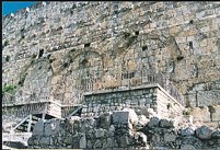
These
gates are
located on the south wall of the Temple Mount.
Triple gate vaults are located where Solomon's portico would have been built on the east wall of the Temple complex. In its day it would have been an open-aired portico/porch/cloister. A covered area from which one could enter the East Gate, which opened up to a beautiful courtyard (later becoming the Woman's Court) of the Temple complex.
This
building was needed because of the steepness
of the hill, and the
high elevation, of the complex above the Kidron Valley. The porch had a
southern entrance because of that hill, and once inside the portico, on
the western side, was the east gate. The King's entrance to the
courtyard. At the western end of the courtyard were beautiful
semi-circled steps leading up to the Temple court.
Below I have drawn the gates in place.
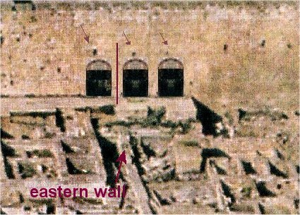
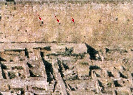
Notice the western gate is on the west side of the east wall in my theory and the other two gates are on the eastern side of the east wall of the Temple complex. The two western arches have steps going down and the arch on the east does not. This means that the western passageway was within Solomon's temple, part of the eastern court of the gentiles, and the other two were the porch or portico outside the temple complex.
This row of arches actually acted as the eastern wall for this section of the temple complex.

Only the top portion of the arches can be
seen above
the dirt and rubble in these passages.

There were deep valleys on the west and east of the threshing floor that King David had purchased, Solomon had to come up with some pretty ingenious ideas to add a huge building east of the Temple.
Warren's
map shows the substructure of Triple Gate and also the
substructures to the east side of Triple Gate, which was dubbed
"Solomon's Stables" by the Crusaders. Solomon's Stables were
built a
thousand years later, with recycled Herodian stones to create a new SE
corner, but
for Solomon he built to the edge of the valleys as far as he could
go.
Triple Gate was once Solomon's Porch spoken of in the Gospels, but what was it called in the Scriptures of the Old Testament?
I believe it was the House of the Forest of Lebanon and also contained Solomon's Porch of Judgment. This is my theory and it remains a "what if".
The House of the Forest of Lebanon is thought to also have been an Armory because Solomon stored 200 solid gold targets, which was a shield large enough to cover a man when kneeling on one knee, and also 300 solid gold shields. The house was also thought to be a banquet hall because all the vessels of the House of the Forest of Lebanon were of gold, no silver. It may have served for both purposes.
This is a drawing of the Portico of Solomon as being viewed from the Mt of Olives with the third isle, western vault, still in tact.
In the scripture it speaks of 4 rows of 15 pillars/piers equals 60 pillars, only 3 of the rows were roofed with cedar by Solomon, only covered 45 of the 60 pillars.
So one row of pillars remained uncovered. This was a popular thing to do in those times, to have a courtyard with pillars before it, not roofed and yet still with the open beams for beauty, and then covered, or roofed pillars, behind that and they are called the side chambers (side chambers because the entrance to the building was on the south). Since the building lay longways north to south facing the courtyard and the Temple House, then this courtyard would evolve into the Woman's Court with the beautiful semi-circle steps leading up to the upper courts and Temple House. In front of the house of the Forest of Lebanon and the Porch of Judgment was a porch and a row of pillars running the whole length of the buildings, and a threshold in front of the pillars. This would be speaking of the threshold of the East Gate. In the western side of Triple gate between the third and fourth piers is the lintel, a horizontal block that spans the space a large gate, but the gate is buried beneath the dirt and debris which fills Triple Gate. Some suggest that it was a two story building, with the upper story built of wood, and so that is how I have drawn it.
In this drawing the East Gate can be seen at the far end of triple gate, on the western most wall, as an entrance into the Woman's court. Both the scripture, which speaks of a threshold, and Charles Warren, who tells of a lintel of a large gate, now buried below the rubble in triple gate, and also Barclay, who speaks of a doorway, are referring to a gate in the west wall, which just happens to be straight across from where I propose the Temple House once was. Just as it should be.
The excerpt below is part of the description Warren gave after being led through the substructure of the terraced area of the south east corner called Solomon's Stables. Warren is then lead into the area of the Triple Gate:
"higher
up (the west wall)
there is a hole on the
right-hand side, partly excavated in the rock, and beyond this on the
left
there is, in the side of the wall, either
a large stone or a portion of the natural rock which looks very like
the
lintel of an old doorway.
The
surface of the rubbish rises to the under side of this, but a stick
between
three and four feet long could be pushed in horizontally, and the
ground
beneath appeared to be soft; the distance between the vertical joints
was
18 feet 2 inches.
(13 cubits @ 18" cubit)

This is what it would have been shaped like before the destruction of 70 AD, although just one big building with vaulted stone ceilings.
The
Destruction of the House of the
Forest of Lebanon and the Porch of Judgment
What remained were the pillars, or rectangle piers, that were once covered with beautiful cedar from Lebanon. With widows of light row upon row it created an open-aired portico. What remained was the piers, and at some point vaults of stone were built above them, with arches, and it all became one building, as it was in the 1st century known simply as Solomon's Porch (i.e. New Testament) After the destruction of the Temple in 70 AD the vaults and arches of the east and west walls were blocked up with stones and it became no more than an underground substructure. This structure of Triple gate was used to raise the mount level up to the flat surface that we see today. I believe this was done by Emperor Hadrian so he could build his Temple of Jupiter above. The same reason is give for the arches of Solomon Stables, which was built of recycled Herodian stones most likely by Hadrian, from a tower at the SE corner to the Hasmonean straight joint in the east wall. This, and the new south wall, completed the huge rectangle of the Temple Mount. See chap 4 of my free on-line book.
The Large Stone in Triple
Gate
I have two theories concerning this stone. The first is that it is called a pillar in scripture, but the word pillar can also mean “platform or pedestal". A six foot platform that if a king would stand upon and be seen above the crowd. It would also be where a prince would stand during the coronation to be crowned king.
|
|
2Chr 23:13 And she looked, and,
behold, the king stood at
his pillar at the entering in, and
the princes and the trumpets by the king: and all the people of the
land rejoiced, and sounded with trumpets, also the singers with
instruments of music, and such as taught to sing praise. Then Athaliah
rent her clothes, and said, Treason, Treason.
2Kings 23:3 And the king stood by a pillar, and made a covenant before the LORD, to walk after the LORD, and to keep his commandments and his testimonies and his statutes with all their heart and all their soul, to perform the words of this covenant that were written in this book. And all the people stood to the covenant. |
In both of these verses the words, stood "by ” were added to the original and could easily read as stood "on". Of course it would be hard to visualize a man standing upon a pillar, which were usually 18 feet tall at that time, but he could stand on a platform that was only 6 feet tall.
My second thought is that this could have been the platform where Solomon placed his throne in the Porch of Judgment. There were 6 steps leaded up to the throne, so we know it was on a platform.
* Judging from appearances these piers may all be ascribed to Solomon or his immediate successors, though the vaults are apparently more modern. The City of the Great King, pg 589
Solomon's Palace
Quote: After building the Temple, Solomon also erected a palace, a hall of justice, an armory (house of the Forest of Lebanon), and other administrative buildings on Mount Moriah.
Solomon's palace was built at a lower elevation just southeast of the Temple.
From 1968 to 1977, large-scale excavations took place in Jerusalem along the southern wall of the Temple Mount and the southern portion of the western wall. In the area of the Ophel, south of the eastern Hulda Gate (Triple Gate), remains of a royal building complex of the First Temple period were discovered.
Further evidence of the Davidic dynasty was found in 1986 by archaeologist Eilat Mazar. Digging on the southeast Ophel slope, she discovered an eighth-century B.C. gate that may well have led to the First Temple area. Beyond it: an area that appears to have been a royal administrative center.
Major construction units of this area from the outset of construction in the First Temple period: two towers, a gate, and an adjacent royal building, apparently first built in the 9th century BCE.
Update 2013-EilatMazar conducted another dig in that area and revealed the-SolomonicWall-RoyalComplex-of Solomon's Palace.|
BOOKS  
"Locating
Solomon's Temple" |
Locating
Solomon's Temple
NOW ON VIDEO!
 |