Home Temple
Videos On-line Book
Herod's Temple in 3D About the
Author


Research Menu
The
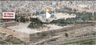
Ophel Ruins
In my
research
I found so much evidence in the ruins on the Ophel, the ruins under the
Mount, and in the writings of the Jewish people, to prove that this was
where the southern court of first and second Temple complex was
located.
I can only hope that when you finish reading this site you will come to
the same conclusion.
Josephus,
a Jewish historian, that lived during the destruction of the Temple
wrote.....The
Wars of the Jews, Book 5 chp 5,8 "for
the temple was a fortress that guarded the city, as was the tower of
Antonia
a guard to the temple;
and in that tower were the guards of those three.
........that hill on which the tower of Antonia
stood was the highest of these three.
The highest hill on the eastern ridge is where the Dome of
the Rock is located.
The
Wars of the Jews, Book 5 chp 4, 2.
.................... It was Agrippa who encompassed the parts added to
the old city with this wall, which had been all naked before; for as
the
city grew more populous, it gradually crept beyond its old limits, and
those parts of it that stood northward of the temple, and
joined
that hill to the city, made it considerably larger, and occasioned that
hill, which is in number the fourth, and is called "Bezetha,"
to
be inhabited also. It lies over against (across
from) the tower Antonia,
but
is divided from it by a deep valley, which was dug on purpose
(a
moat), and that in order to hinder the foundations of the tower
of
Antonia from joining to this hill,
Most
people place Fort Antonia on the hill Bezetha. As we can see this is
incorrect
according to Josephus. It (Bezetha-New
City) lies over against (across from) the tower
Antonia,
but
is divided from it by a deep valley, which was dug on purpose
(the
moat)
That
places the location of the Temple as being South of the Dome of the
Rock
area.
The city
of David was on a hill with valleys surrounding it on three sides, but
on the north was the weak spot in it's defense. It was
there
that the Temple was built and surrounded with very high walls, as a
fortress.
Beyond that, but connected to it, a tower was erected on the highest
rocky
hill. Later this tower was added to becoming a fort also called
Fort
Antonia. To further fortify the Temple and City from a northern
attack
a 200 foot moat was dug north of that, separating this hill from the
hill
Bezetha. An army attacking the City of Jerusalem had to
fill
in the moat, destroy the walls of Fort Antonia, before they could take
the Temple. Which Titus and his army actually did in
70 AD.
Where
is that second hill that Josephus spoke of?
The
hill of "The Temple,
from which the city was guarded"
Ophel
is the hill that lies between the highest hill and the old city of
David
below, just as Josephus described.
On
Ophel hill a person can view a gigantic mass of bedrock protruding out
of the hill. It is 215 feet wide and 22 feet high. On the
face
of that massive rock either King David, or Solomon, cut huge steps
leading
to the top of it.
It
has been suggested that the steps lead up to tunnels, passageways,
which
the people walked through to get up to the surface of the Temple
Mount.
But there is NO record of these tunnels in all of history.
In fact these passages, under Al-Aksa Mosque, are proved to have
been constructed after the destruction of the Temple in 70 AD.
Ophel
ruins at the Southern wall

The ancient steps, cut into the bedrock excavated
in 1967
Quote; The massive stairs lead up to the platform.
["The large monumental stairway just to the south of the Double Gate
was
excavated.] This stairway of 30 steps is 215 feet wide, paved
with
smoothly trimmed stones, and its FOUNDATION STEPS ARE CUT INTO
THE
BEDROCK. From a wide plaza below on the south…the STAIRWAY
ROSE
22 FEET [sic 22-1/2 feet] to the UPPER STREET [the
rampart/platform]
in front of the Double Gate" [W. Harold Mare, The Archeology of the
Jerusalem Area, p. 154; see also Benjamin Mazar, The Mountain
of
the Lord].
|
King
David purchased a threshing floor north of, and above, the City
of
David and on that foundation rock he built an altar to God. And before
the altar his son built the House of God and in it he placed the Ark of
the Covenant.
I
believe those steps lead up to the threshing floor of David. The second
hill Josephus spoke of, where the Temple once stood.
If that is the case, and I believe I have proved that it
is,
then the Ophel Excavations are part of the old Temple
Complex.
|
Below is a Close-up of the
right lower
corner of the Ophel Ruins with its gates and walls of
ancient times. They
tell a wondrous tale.

Ophel
ruins
|
By laying the lower right
corner of the
above diagram over this photo, the ruins reveal they
were
part of the Temple compound.
Herod's southern gate was in
the center of the 600 foot south wall of the temple compound |
Also see; Collapsed Ruins on the Ophel and Those Strange Arches
Click Here
|
New
photo of Ophel ruins
Click here
|
Sir Charles Warren's
Survey Map
with temple diagram overlays
The
drawing not only fits the shape of the ruins of the Ophel but also the
underground ruins shown by Warren. This map shows only
some
of the ruins, both above ground and below, that are easily identified
when
my design is placed over the top.


Click
on Maps for larger image
From the
ruins of the North gate to the ruins of a South gate and from the ruins
of Robinson's arch to Triple gate they form a perfect square 600 X
600
feet! This is also not a coincidence
Most of
the old Solomon temple walls (in green) were removed by Herod.
According
to historical accounts Herod's temple area was around 187x187 meters
square
(at 44 cm per cubit, 17.5 inches per cubit, approximately 600
feet).
|
Latest Updates
|
BOOK
"Locating
Solomon's Temple"
by Norma Robertson
|
Locating
Solomon's Temple
NOW
ON VIDEO!
|