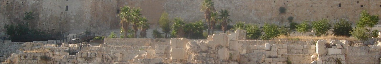
Temple Mount View from the West
I have already
established
that Josephus wrote that Fort Antonia was located on the highest hill.
There
are a few more
key questions that
when answered will tell us the exact location of Fort Antonia.
The best
way to
understand where the fort was located
is to read through Josephus' account.
1.
How
big was the
temple compound and Fort Antonia altogether?
Josephus says it was
"six furlongs around,
including fort Antonia"
The Wars of the
Jews, Book 5, Ch 5
2. ...........The
cloisters
[of the outmost courts] were in breadth thirty cubits, while the
entire compass of it was by measure
six furlongs, including the
tower of
Antonia; those entire
courts that
were exposed to the air were laid with stones of all sorts.
Update-May, 2021: "In the early Roman Kingdom legion may have meant the entire Roman
army, but sources on this period are few and unreliable.[1] The
subsequent organization of legions varied greatly over time but legions
were typically composed
of around five thousand soldiers. During much of
the republican era, a legion was divided into three lines of ten
maniples. In the late republic and much of the
imperial period (from
about 100 BC), a legion was divided into ten cohorts, each of six (or
five) centuries. Legions also included a small ala, or cavalry unit." 27
BC – AD 476
https://en.wikipedia.org/wiki/Roman_legion
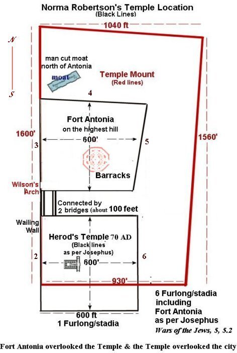
While building the 3D of the Temple I found that enough barracks, and
land area needed for the Legion and cavalry, were very possible within 600' x 600'
area.
With this lower
placement of the Temple compound and also the
placement of Fort Antonia on the Dome of the Rock platform the
measurement all
the way round is 6 furlongs just as Josephus said it was. According to
Josephus
the Temple compound alone was a furlong by a furlong, that is approximately
600 x
600, but when Fort Antonia's colonnades were included in with the Temple
complex, together
it was s 6 furlong around. So Fort Antonia was also squarish
of 600 x
600 (not counting the bridges that went from the fort to the Temple). (Josephus-war of the Jews 5.2)
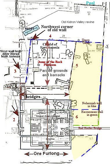
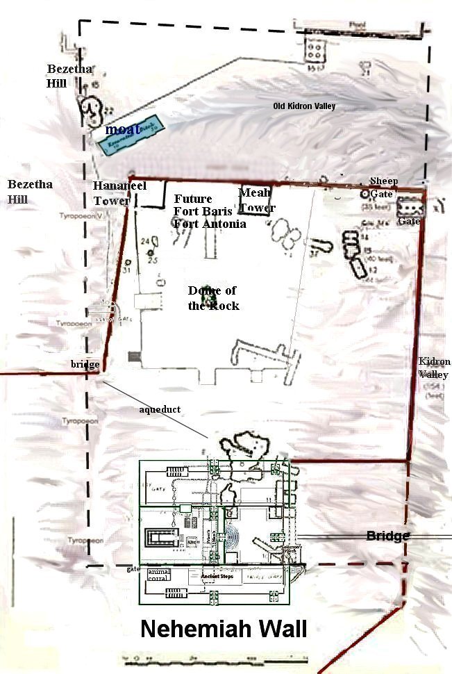
It is
interesting to trace the changes in the area from the time that
Nehemiah
rebuilt the city wall all the way up to when Josephus describes Fort
Antonia as
it was before the destruction of 70 AD. If we begin with the
north wall
described by Nehemiah with the Tower Meah and Tower Hananeel as the
towers
protecting the Temple from a northern attack.
The above map is as it would have been during the Time of
Nehemiah
Below is First Century BCE
The Meah fortress
was built upon under the
Hasmoneans during the late 2nd century BCE and renamed the Baris. It
was
rectangular and possessed several high towers, one of which was known
as
"Straton's Tower". The Baris was connected to the
Temple
Mount by an underground passageway. The Baris was besieged by
Pompy/ Herod the Great
during his Siege of Jerusalem in 63 BCE, during which one of its towers
was
felled by Roman siege engines. Under Herod the Great, the Hasmonean
Baris
underwent renovation or reconstruction, and it was renamed Antonia in
honor of
his patron Mark Antony.
This allows
for Fort
Antonia to be placed on
the old north wall that Nehemiah rebuilt. Recently coins from
the 1st
century CE were found under the west wall of the Temple Mount that we see
today.
This means that Herod the Great did not build all of the west wall of toady's
Temple
Mount. It was built by his grandson or great grandson, many
years after
Herod the Great finished Fort Antonia and the Temple. The west wall of
today
was built deep into the Tyropeon Valley. The old west wall (pre-Herod was
built up to the
edge of that valley.
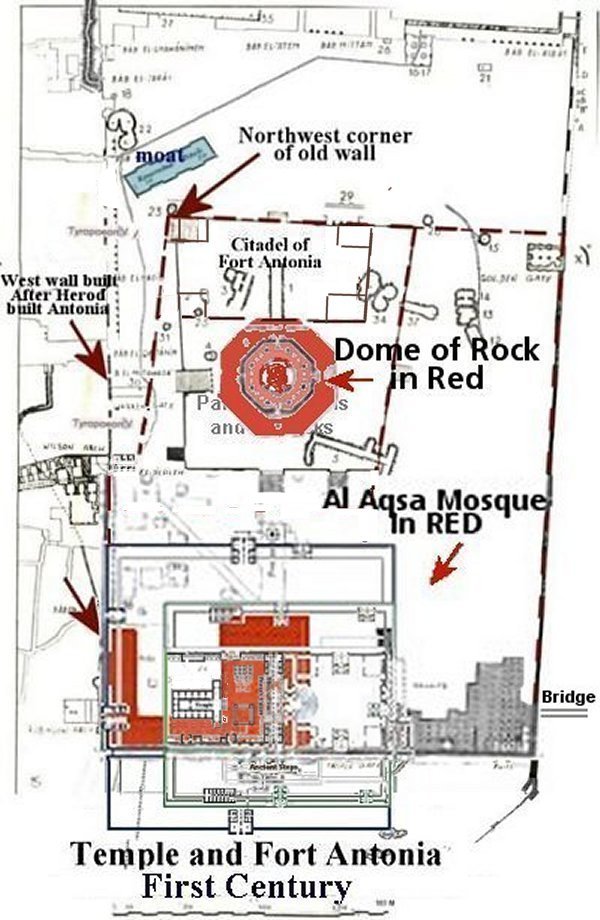
It is my belief that
the walls of Fort
Antonia were at a Northwest angle to the Temple. The reason is because
of the
steps at the northwest corner of the platform of the Dome of the Rock.
The
bottom step is not a step at all. It is the top of a very old wall.
That wall
is angled and my red dashed line in the below map, showing the old west
wall,
follows that same angle.
2.
How
was the fort
attached to the Temple compound?
Josephus Flavius in 93 C.E.
War
of the Jews Book 5, Chp. 5
Josephus
Flavius regarding Tower of Antonia;
8.
Now as to the tower of Antonia, it was
situated at the corner of two cloisters of the
court of the temple; of that on the west,
and that on the north;
it was erected upon a rock of fifty
cubits in height (75 feet
high), and was on a great precipice; (steep
hill) it was the work of king
Herod, wherein he demonstrated his natural
magnanimity.
.......but
on the corner where it joined to the two cloisters of the
temple, it had passages down to them both, through which the
guard (for there always lay in this tower a Roman
legion) went several ways among the cloisters, with their arms, on the
Jewish
festivals, in order to watch the people, that they might not there
attempt to
make any innovations;
Josephus
quoted an old
Jewish prophecy that said "When the
Temple becomes four-square once again then will
the temple and city be destroyed."
War
of the Jews Book 6, 2, 9
they
set the north-west cloister,
which was joined to the tower of Antonia, on fire, and after that brake
off
about twenty cubits of that cloister, and thereby made a beginning in
burning
the sanctuary; two days after which, or on the twenty-fourth day of the
forenamed month, [Panemus or Tamuz,] the Romans set fire to
the cloister
that joined to the other, when the fire went fifteen cubits
farther. The
Jews, in like manner, cut off its roof; nor did they entirely
leave off what
they were about till the tower of Antonia was parted from the temple,
With this
act the Temple
was once again four-square.
The
Temple Aqueduct
Rendition
of the Temple
Herod
had built the
new temple prior to the
birth of Jesus, but the new walls of Herod's extended courts were built
by
Herod's decedents during the first century. When
Jesus visited the
Temple during His ministry (26-30 AD) the extended courts were still
under
construction and were not finished until 66 AD. Before the
new walls were
completed Herod's Temple and new buildings remained within the old
walls of the
former Temple, as shown in the digital painting below.
The new walls of Herod's
extended courts, with Royal Stoa, were completed in 66
AD. By 70 AD
it had all been destroyed by Titus.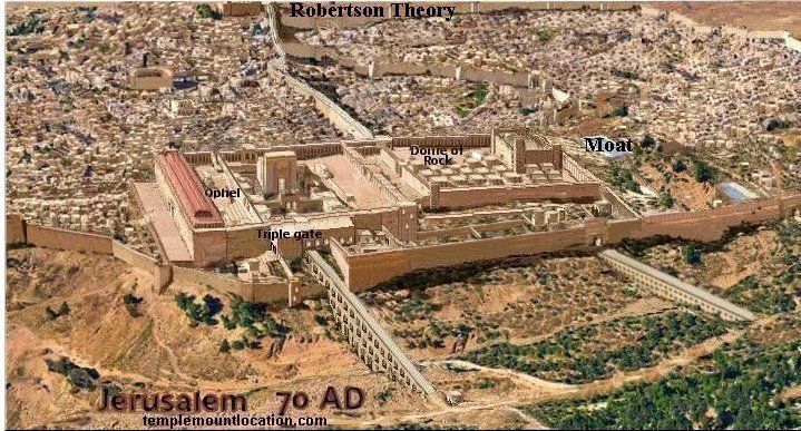
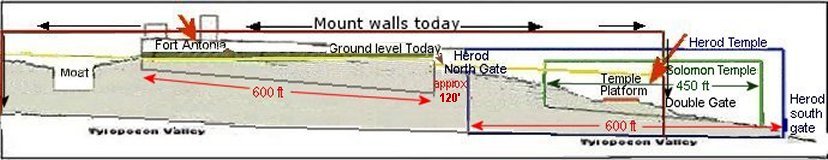
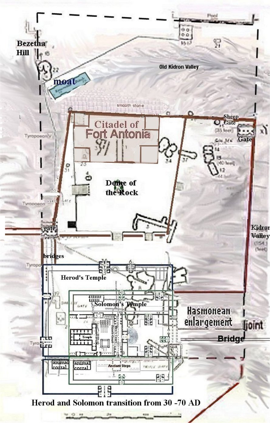
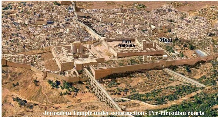
Fort
Antonia contained the citadel, a tower
or fortress, which was within other towers, as described by
Josephus. In other
words a fortress within a fortress. He leaves 600 x 600 feet
to be the
size of the whole area belonging to Fort Antonia by telling us that the
Temple
was 6 furlong around, including Fort Antonia. That is 600' x 1200' around. The Wars of the
Jews, Book 5, Ch 5
This
is how I showed it be in my digital painting
above.
War
of the Jews Book 6, 2. 5.
As Josephus explained these things from the mouth of Caesar, both the
robbers and the tyrant thought that these exhortations proceeded from
Titus's fear, and not from his good-will to them, and grew insolent
upon it. But when Titus saw that these men were neither to be moved by
commiseration towards themselves, nor had any concern upon them to have
the holy house spared, he proceeded unwillingly to go on again with the
war against them. He could not indeed bring all his army against them, the place was so narrow;


6.
....... Now,
it so happened, that this fight was for the most part a stationary one,
wherein the soldiers went on and came back in a short time, and
suddenly; for there was
no long space of ground for either of their flights or pursuits.
But still there was a tumultuous noise among the Romans from the tower
of Antonia, who loudly cried out upon all occasions to their own men to
press on courageously,
7. In the mean time,
the
rest of the Roman army had, in seven days' time, overthrown [some] foundations
of the tower of Antonia, and
had made a ready and broad
way to the temple. The
one bank was over against the north-west corner of the inner temple
another was
at that northern edifice which was between the two gates; and of the
other two,
one was at the western cloister of the outer court of the temple; the
other
against its northern cloister.
The
Roman's had taken Fort Antonia and at this point in the
battle seems to
have been fighting within the narrow strip of land between the southern
wall of
Fort Antonia and the northern wall of the Temple.
This is the strip
of land that the colonnades spanned, (connecting the Temple to Fort
Antonia at
the Temples west and north walls) but once of the stones of
wall of Fort Antonia
were overthrown making a broad way for his army then Titus was able to
defeat the Jews and take the Temple.
3.
Was
there a low wall
surrounding the Rock creating a platform?
Josephus
continues:
....In the first
place, the rock
itself was
covered over
with smooth pieces of stone, from its foundation, both for
ornament, and that any one who would either
try to get up or to go down it
might not be able to hold his feet upon it.
This
would mean the sides of the 74 foot
hill was covered with smooth stones so that if anyone try to
climb up to
the fort they would slip on the smooth stone and not be able to get up
the
steep hill to the base of the Fort.
Next to this, and
before you come to the edifice of the tower itself, there was
a wall three cubits high; (4.5 feet high) but within
that wall all the space of the tower of Antonia itself was built upon,
to the
height of forty cubits (60
feet).
A 4.5
foot wall surrounded
the upper part of the hill and the fort was built within that
wall. This
would mean that land fill was placed within the bounders of this low
wall to
create a flat spot to build the Fort.
4.
What
were the
dimensions?
Josephus Flavius, Antiquities Book 15
Chp 11,
4.
Now on the north side was built a citadel,
whose
walls were square, and strong, and of
extraordinary firmness. This
citadel (Baris) was built by the kings of the Asamonean race,
who were
also high priests before Herod, and they called it the Tower, in
which were reposited the vestments of the high priest, which the high
priest
only put on at the time when he was to offer sacrifice.
...............But
for the Tower itself, when Herod the king of
the Jews had fortified
it more firmly
than before, in
order to
secure and guard the temple, he gratified Antonius, who was his friend,
and the
Roman ruler, and then gave it the name of the Tower of
Antonia.
Josephus Flavius
regarding Tower of
Antonia, the height of the fortress and its towers.
Josephus
continues speaking of Fort Antonia:
War
of the Jews Book 5, Chp. 5
8. ......The
inward
parts had the largeness and form of a palace, it being parted
into all kinds
of rooms and other conveniences, such as courts,
and places for bathing,
and broad spaces for camps; insomuch that, by
having all conveniences
that cities wanted, it might seem to be composed of
several cities,
but by its magnificence it seemed a palace. And as the entire structure
resembled that of a tower, it contained also four other
distinct towers at
its four corners; whereof the others were but fifty
cubits high;
whereas that which lay upon the southeast corner was
seventy cubits high, that from thence the whole
temple might be viewed;
·
The
rock
on which the fortress was built was 50 cubits high (74 feet) (We can assume he
was measuring from
Barkley gate which was street level in the Tyropeon valley ,which is
approximately 50 cubits lower than the rock inside the Dome.
Barkley gate
721.3 M (2366.4 feet) above sea level. Rock 743.7 M (2440.0 feet) above
sea level)
· The
height of the fortress itself was 40 cubits (58 feet)
·
and
it
had 4 other towers, one in each corner.
·
The
height of three of the towers was 50 cubits (74 feet) and the fourth (southeast corner) tower was 70 cubits
(102
feet - one could see inside the
Temple fortress from that tower)
·
The
Antonia Fortress was a military fortification and Josephus said that
the whole
Fortress of Antonia appeared as one tower.
|
Measurement
increments used in the
map and drawing above.
1 cubit =
Hebrew (short) = 44.5 cm
= 17.5"
Royal cubit =
Hebrew (long) = 51.8
= 20.4"
Roman cubit =
44.4 cm = 17.4"
1 cubit
= 50.0 cm. =
19.8 the length of the cubit according to Warren
(Warren, The
Underground Jerusalem, p. 67)
furlong 600+
feet Stadium 607
feet riz 600 feet = 182.8 meters
|
8. .......for the
temple was a
fortress that guarded the city, as was the tower of Antonia a
guard to the temple; and in that tower were
the guards of those three.
What
valley's were on
the East and West of the fort?
Josephus
gave the details;
- The
Fortress of
Antonia was partly surrounded by a deep ravine 165 feet wide. (Kidron)
(see map)
- The
western wall was
built upon the edge of the cliff overlooking the Tyropeon Valley. (See
map)
Where
was the moat and on which side of the moat was the fort built on?
- The north wall was
directly across from the hill Bezetha and there was a
deep mote between them.
The Fort Antonia hid the Temple from the hill Bezetha. (see above map
for location of that city at the top of the map)
- The
southern wall of
Fort Antonia one could see over the entire Temple area.
- The
eastern wall
overlooked the Pool of Bethesda and the Kidron Valley. (see map to see
the the angle of the pool from the fort.)
The
Moat
A
ditch nearly 200 feet
long
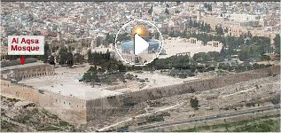
The Dome of the Rock theory
places the Fort on the wrong side of
the moat!
War of the Jews Book
5 Chapter 4
2.
.................... It was Agrippa who encompassed the
parts added to the old city with this wall, which had been all naked
before;
for as the city grew more populous, it gradually crept beyond its old
limits,
and those parts of it that stood northward of the temple, and joined
that hill
to the city, made it considerably larger, and occasioned that hill,
which is
in number the
fourth,
and is called "Bezetha,"
to be inhabited also.
It
lies over against
(across
from) the tower Antonia, but is divided from
it by a deep
valley, which was dug on
purpose, and that in order to hinder the
foundations of the tower of Antonia
from joining to this hill, and
thereby affording an opportunity for
getting to it with ease, and hindering the
security that arose from its superior elevation; for which reason also
that
depth of the ditch (moat)
made the elevation of the towers more remarkable. This new-built part
of the
city was called "Bezetha," in our language,
which, if interpreted in
the Grecian language, may be called "the New City."
Josephus, in
his description of
the siege of the Temple by Pompey, BC 63, says that the Roman
Commander
found it impossible to
attack it on any other quarter than the north, on account of the
frightful
ravines on every other side; and that even on this side (north side) he
had
to fill up "the fosse (moat)
and "the whole of the ravine,
which lay on the north quarter of the Temple;"
and in the description
of the
siege of the Temple by Herod,
BC 38, 37, he says, that Herod made the attacks in the same manner as
did
Pompey, that is, from the north side of it.
When he comes to the
description of the siege by Titus, AD 70,
the Temple with its enclosure, and the tower of Antonia at the
north-west angle
of the enclosure, having been entirely rebuilt by Herod, BC
17, Josephus
says that the design of Titus was
"to take the Temple at the tower of Antonia;" and that for
this
purpose he raised great banks; one of which was at
the tower of Antonia,
and the other at about 20 cubits from it; and that for the
purpose of
obtaining materials or filling up the immense fosse and
ravine to the north of the Temple, he had to bring
them from a great distance; and that
the country all round for a distance of 19 or 12 miles was made
perfectly bare
in consequence.
Here
is a quote from the web page of by Lambert Dolphin and Michael Kollen
1.
Where was the Antonia Fortress?
Ancient
Jerusalem was protected on the east, south, and west by
valleys. The Antonia Fortress was located to the north to protect the
weaker
north side of the city. (In fact, it was from the north that Titus
Vespasian
breached the walls in his famous attack in 70 C.E.)
According to ancient
sources, the fortress was on a hill about
25 meters high. The current El Omriah school building is on a rock only
5
meters high. From many stratographic and other considerations it is
doubted by
some experts that this was the actual location of the Antonia Fortress.
Tuvia
Sagiv's papers discuss the critical issue of the actual location of the
Fortress Antonia, which he believes was well to the south, perhaps
at the
location of the Dome of the Rock.
2. The
Location of the Ancient North Moat (the Fosse)
Traditional
renderings show a deep, filled-in fosse (moat),
north of the Temple Mount, lying south of the Antonia Fortress, between
the
fortress and the Temple Mount.
According to ancient
sources, however, the Antonia Fortress and
the Temple Mount were adjacent to each other. The moat should be to the
north
of the Tower for protection, placing the Antonia about where the Dome
of the
Rock stands today! End quote
The
Straight Joint
From
the south-east corner of the present-day Temple Mount, the eastern wall
shows
Herodian masonry for some 106 feet. At that point a seam, or straight
joint, is
visible, to the north of which Hasmonean masonry appears followed by
the oldest
masonry believed to perhaps be that of Hezekiah. All of the upper
courses of
the wall are muslim.
The
Secret Passage
THE
ANTIQUITIES OF THE JEWS
Book 15, Chapter 11
7.
There was also an occult (underground)
passage
built for the king; it led from Antonia to the inner temple, at its
eastern
gate; over which he also erected for himself a tower, that he might have
the opportunity of a subterraneous
ascent to the temple, in order to guard against any sedition which
might be made
by the people against their kings.
Warren's
Description of a passage
Cistern
No. V, under
platform to
the south-east of the "Dome
of the Rock," descended; 48 feet deep, 2 feet water. This cistern has a
curious cruciform shape; at the eastern end a low doorway cut in the
rock leads
to a flight of steps, which after ascending some distance in a
southerly
direction, turns sharp off to the east, and communicates with
a subterranean
passage; the passage is covered by a semicircular vault, and
at its entrance
to the cistern are the remains of a doorway; on the floor there was a
thick
slimy deposit, and a few yards beyond the doorway the opening was
blocked up by
earth; there are two openings to the cistern in use and one closed,
below one
of the former a rough basin has been made to collect the water from the
different branches. No conduit could be seen entering the cistern; the
roof of
the south-eastern branch is of rock, but there was not sufficient light
to see
what that of the other portion was made of.
North of the Temple
The Baris,
had also occupied a location
overlooking the Temple's precincts. It stood north of the Temple
on the site later occupied by the Antonia Fortress.
"The
Baris fell
to Antiochus
III the
Great (198 BC taking it from the Egyptians) and is absent
from all accounts
of Maccabean Revolt.
Pompey
(63 BC)
105
years later; When Pompey arrived in Jerusalem, he surveyed
the city: for
he saw the walls were so firm, that it would be hard to overcome them;
and that
the valley before the walls was terrible; and that the temple, which
was within
that valley, was itself encompassed with a very strong wall, insomuch
that if
the city were taken, that temple would be a second place of refuge for
the
enemy to retire to. (Josephus, The Wars of the Jews 1:141)
Fortunately
for Pompey, Hyrcanus II still had
supporters in the city. They opened a gate, probably situated in the
northwestern part of the city wall, and let the Romans in. This allowed
Pompey
to take hold of Jerusalem's upper city, including
the Royal Palace,
while Aristobulus' party held the eastern portions of the city—the
Temple Mount
and the City of David. The Jews
consolidated their hold by breaking down the
bridge over the Tyropoeon Valley connecting the upper city with the
Temple
Mount. Pompey offered them the chance to surrender, but when they
refused, he
began prosecuting the siege with vigour. Pompey had his forces
construct a wall
of circumvallation around the areas held by the Jews and then pitched
his camp
within the wall, to the north of the Temple.
Here
stood a saddle allowing access to Temple, and it was
therefore guarded by the citadel known
as the Baris, augmented by a ditch
(moat).
The troops
then set about filling the ditch
protecting the northern part of the Temple enclosure and building two
ramparts,
one next to the Baris and the other on the west,
while the defenders,
from their superior position, sought to hinder Roman efforts. When the
banks
were complete, Pompey erected siege towers and brought up siege engines
and
battering rams from Tyre. Under the protection of slingers driving the
defenders from the walls, these began to batter the walls surrounding
the
Temple. After three months, Pompey's troops finally managed
to overthrow
one of the Baris' towers and were able to enter the
Temple precinct,
both from the citadel and from the west.
Pompey
himself entered the Temple's Holy of Holies which only the High Priest
was
allowed to enter, thereby desecrating it. He did not remove anything,
neither
its treasures nor any funds, and the next day ordered the Temple
cleansed and
its rituals resumed. Pompey then headed back to Rome, taking
Aristobulus with
him for his triumphal procession.
Latest
Updates
Herod's Temple and Fort Antonia in 3D. Walk through the Temple in this narrated tour.
 Playlist (38
minutes) YouTube channel NormaR346
Playlist (38
minutes) YouTube channel NormaR346
Locating
Solomon's Temple
by Norma Robertson
NOW ON VIDEO!
BOOK
"Locating
Solomon's Temple"
by Norma Robertson
|